
Google Maps Users Thought They Found a Black Hole in the Pacific—The Truth Was Even More Fascinating
The Ominous Dark Shape Sparked Theories About Censorship and Secret Bases, but It Was Actually One of the Pacific’s Most Remote Islands
At first glance, the image looked unsettling.
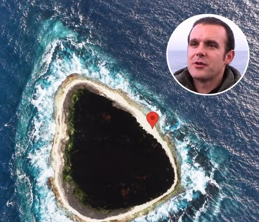
In the middle of the vast blue Pacific Ocean sat an almost perfectly dark shape.
Bright surf surrounded it.
Beyond that was nothing but ocean.
From above, the center looked less like land and more like a hole punched directly into the sea.
When the image began circulating online, speculation spread quickly.
Was Google hiding something?
Was it a secret military installation?
A volcanic crater?
Or had satellite imagery somehow captured something far stranger?
The real explanation turned out to be much less sinister—but no less remarkable.
The “Black Hole” Was Vostok Island
The mysterious dark shape is Vostok Island, an uninhabited island belonging to the Republic of Kiribati in the central Pacific.
Fact-checkers later confirmed that the strange Google Maps image was not a censored location or digital void. The island simply appeared extraordinarily dark because of the dense vegetation covering its interior.
From satellite altitude, that vegetation absorbs so much visible light that the island can appear almost black against the surrounding turquoise water.
Its Appearance Helped Fuel Years of Online Rumors
The unusual image drew widespread attention after appearing online in 2021.
People proposed explanations ranging from an underwater hole to a hidden military facility or a place deliberately obscured by Google.
But there was no mysterious censorship involved.
The dark triangular patch was simply a tiny coral island covered almost completely by trees.
Vostok Is Extremely Remote
Vostok is part of Kiribati’s Southern Line Islands, a chain of tiny islands located thousands of kilometers south of Hawaii.
The region is so isolated that scientists have described its reefs as some of the least disturbed marine ecosystems remaining in the Pacific.
That isolation is one reason the island looks almost untouched from above.
There are no cities.
No roads.
No neighborhoods.
No bright coastal development.
Just dense vegetation surrounded by reef and ocean.
The Darkness Comes From Vegetation, Not a Hole
Vostok’s interior is heavily covered by trees and other vegetation.
Seen from orbit, the dense canopy forms a dark mass with little visible variation.
Surrounding waves and shallow reef water create a bright border around the island, making the contrast even stronger.
That combination produces the illusion that the center is missing entirely.
It is easy to understand why people unfamiliar with the island thought they were looking at something impossible.
Scientists Had Already Visited the Region
Long before the Google Maps mystery became an internet phenomenon, scientists and explorers were studying the Southern Line Islands.
National Geographic Explorer Enric Sala led expeditions to the region beginning in 2009 as part of efforts to understand some of the world’s healthiest remaining coral ecosystems.
The waters around Vostok were anything but empty.
They were overflowing with marine life.
One Explorer Called It the Best Dive of His Life
After diving at Vostok, Sala described the experience in exceptionally enthusiastic terms.
He said it had been the best dive of his life and described waters filled with sharks, barracuda, surgeonfish and large schools of other fish.
That description could hardly be further from the ominous theories inspired by the satellite image.
The “void” was surrounded by one of the richest marine environments the team had encountered.
The Southern Line Islands Are Known for Extraordinary Reefs
National Geographic has described the Southern Line Islands as among the most pristine archipelagos remaining in the Pacific.
Scientists found unusually healthy food webs there, including large populations of top predators such as reef sharks.
In healthy reef systems, predators can be extremely abundant because the entire ecosystem beneath them is productive enough to support them.
That makes places like Vostok valuable natural laboratories.
Vostok’s Reef Later Survived a Major Climate Shock
The region has not remained untouched by global environmental change.
The powerful 2015–2016 El Niño caused widespread coral mortality across parts of the Southern Line Islands.
When scientists returned years later, however, they found that reefs around Vostok and neighboring islands had recovered to a remarkable degree.
The recovery became an important example of how protected ecosystems can sometimes show extraordinary resilience when other human pressures remain limited.
Researchers Returned Again in 2023
National Geographic’s Pristine Seas team revisited Vostok, Flint and Millennium islands in 2023.
Over just more than two weeks, the expedition carried out hundreds of dives and hundreds of hours of underwater surveys.
The goal was to study how these remote reefs had recovered after extreme warming.
The findings reinforced the importance of keeping these ecosystems protected.
The Waters Remain Filled With Predators
Recent National Geographic imagery from Vostok shows gray reef sharks swimming through dense schools of smaller fish.
Those predator populations are considered a sign that the reef supports a highly productive and relatively intact food web.
What appears empty and black from space is therefore surrounded by an ecosystem bursting with movement.
Vostok Is Part of a Protected Marine Area
Scientific expeditions to the Southern Line Islands helped support conservation efforts by Kiribati.
Fishing restrictions were introduced around the islands, and the protections later became part of a permanent marine protected area covering thousands of square kilometers.
Those protections are intended to preserve precisely the kind of ecological abundance explorers found around Vostok.
Why Does the Island Look So Different From Other Tropical Islands?
Most people are accustomed to seeing tropical islands surrounded by bright beaches, buildings or visible clearings.
Vostok does not fit that familiar image.
Its dense vegetation reaches close to the shoreline.
There is almost no development to break up the dark canopy.
The bright surrounding reef then exaggerates the contrast.
From a satellite, the result can look unnatural even though it is entirely real.
The Internet Turned an Optical Illusion Into a Mystery
The story is a good example of how satellite imagery can create false impressions.
A single image can lack the context needed to understand scale, vegetation, elevation or lighting.
Once an unusual image begins circulating online, dramatic explanations can spread much faster than ordinary geographic ones.
In Vostok’s case, a tiny forested island became a supposed black hole simply because of how strongly its dark vegetation contrasted with the ocean around it.
The Reality Was More Interesting Than the Conspiracy
There was no secret base.
No portal.
No giant hole in the Pacific.
Instead, the strange black shape revealed something increasingly rare.
A remote island surrounded by reefs rich enough to support sharks, enormous schools of fish and a largely intact marine ecosystem.
The internet expected something sinister.
Vostok offered something better.
It Is a Reminder That Parts of Earth Still Look Alien From Space
Modern satellite imagery gives us the impression that almost every corner of the planet has been completely mapped and understood.
But photographs taken from space can still make natural places look almost impossible.
Vostok Island is a perfect example.
From above, it resembles a dark wound in the ocean.
At sea level, it is simply a densely forested island surrounded by crashing surf.
Below the surface, it becomes something else again—a thriving coral ecosystem crowded with fish and sharks.
The Final Explanation Is Simple
The mysterious black shape seen on Google Maps is Vostok Island in Kiribati.
Its densely vegetated interior makes the land appear extremely dark in satellite imagery, while bright reef water and breaking waves create the illusion of a giant hole surrounded by the Pacific.
Far from being empty, the waters around the island have been documented by National Geographic expeditions as extraordinarily rich in marine life.
What looked like a frightening void from space was actually one of the clearest reminders that some of the wildest places left on Earth can still look almost unreal.